Footpaths flooded in the Chess Valley – UPDATED 5-Sep-24
River levels have dropped slightly. Throughout the parish, the Chess Valley Walk is passable – there are a few softer bits but no more mud than should be expected on any country walk. For more detail, see below…
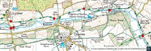
From west to east – the numbers refer to the locations on the map below…
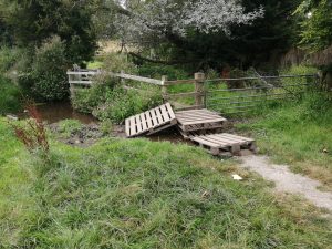
- Chess Valley walk at Latimer Bottom – a new path has been created which loops away from the river and passes above the flooded meadow – this is dry. But pallets have been placed near where the path exits onto the road at Latimer Bottom (see photo) and you have to climb over a fence. If you are not reasonably agile (or wearing wellies or good boots), you may prefer to walk down the road to (3)
- Road at Latimer Bottom – clear
- Bridleway at Latimer Bottom – fairly dry if you stay close to the river
- Upstream of Mill Farm, Chenies – now dry – hard-core has been laid on the lowest-lying sections of the path
- Frogmore Meadow – now dry
- Ford by Watercress Beds, Sarratt Bottom – the river is a couple of inches below the bridge. The paths either side have had hard-core and stepping stones laid on them so are now passable.
- Concrete Bridge, Sarratt Bottom – the path crossing the river towards Turvey Lane Wood is now dry although slightly muddy. The Chess Valley path itself is dry.